National Atlas & Thematic Mapping Organisation
Please turn your device
स्क्रीन रीडर एक्सेस
मुख्य विषयवस्तु में जाएं
नेविगेशन पर जाएं
A
+
A
A
-
Sign up
EN
हिंदी
साइन इन
रजिस्टर करें
Geoportal
राष्ट्रीय एटलस एवं थिमैटिक मानचित्रण संगठन
National Atlas & Thematic Mapping Organisation
Department of Science & Technology,Government of India
होम
ईबुक सेवाएँ
मानचित्रण
कृषि संसाधन का एटलस
ग्रामीण भारत का एटलस
सांस्कृतिक विरासत एटलस
जल विज्ञान एटलस
भारतीय महासागर एटलस
भारत का सिंचाई एटलस
नेशनल एटलस
पहला संस्करण
खंड I
खंड II
खंड III
खंड IV
खंड V
खंड VI
खंड VII
खंड VIII
संशोधित संस्करण
खंड I
खंड II
खंड III
खंड IV
खंड V
खंड VI
खंड VII
खंड VIII
खंड IX
खंड X
विज्ञान और प्रौद्योगिकी भारत के एटलस
सामाजिक आर्थिक एटलस
गोवा का राज्य एटलस
पंजाब का राज्य एटलस
जल संसाधन विकास एटलस
मोनोग्राफ
दिल्ली: शहरों का शहर
पुस्तिका
केदारनाथ
भारत में महिला शिक्षा
भारत में महिलाओं के खिलाफ घरेलू हिंसा
मानचित्रण सेवाएं
सभी
एटलस सेवाएं
इंडियन - एज़ियन आर्कियोलॉजिकल एटलस
इंडियन ओसियन एटलस
कृषि एटलस
ग्रामीण भारत के एटलस
जल विज्ञान एटलस
जल संसाधन एटलस
नेशनल एटलस
पहला संस्करण
आयतन -1
आयतन -2
आयतन -3
आयतन -4
आयतन -5
आयतन -6
आयतन -7
आयतन -8
संशोधित संस्करण
आयतन -1
आयतन -2
आयतन -3
आयतन -4
आयतन -5
आयतन -6
आयतन -7
आयतन -8
आयतन -9
आयतन -10
नेशनल स्कूल एटलस
पर्यटन एटलस
पर्यावरण एटलस
विज्ञान और प्रौद्योगिकी भारत के एटलस
सामाजिक-आर्थिक एटलस
सिंचाई एटलस
स्टेट एटलस
गोवा
पंजाब
महाराष्ट्र
स्वास्थ्य और रोग एटलस
प्रदर्शन
मानचित्र सेवाएँ
जिला योजना मानचित्र श्रृंखला
अण्डमान और निकोबार
आन्ध्र प्रदेश
पूर्व गोदावरी
गुंटूर
खम्मम
कृष्णा
महबूबनगर
प्रकाशम
नेल्लोर
विशाखपटनम
विजयनगरम
वारंगल
पश्चिम गोदावरी
अरुणाचल प्रदेश
चांगलांग
दिबांग घाटी
पूर्व सियांग
लोहित
नीचा सुबानसिरी
तिरप
अपर सियांग
पश्चिम सियांग
असम
बारपेटा
कछार
डिब्रूगढ़
हैलाकांडी
जोरहाट
कामरूप
कार्बी आंगलोंग
करीमगंज
लखीमपुर
नलबाड़ी
उत्तर कैशहर हिल्स
शिवसागर
तिनसुकिया
चंडीगढ़
छत्तीसगढ़
बस्तर
बिलासपुर
दंतेवाड़ा
धमतरी
दुर्ग
जांजगीर चंपा
जोशपुर
कांकेर
कवर्धा
कोरबा
कोरिया
महासमुंद
रायगढ़ 1
रायपुर
राजनंदआंगएओए
सरगुजा
बिहार
भागलपुर
दरभंगा
देओघर (बिहार )
धनबाद(बिहार)
कटिहार
खगरिया
मधुबनी
मधेपुरा
पश्चिम चंपारण
रोहतास
सहरसा
समस्तीपुर
सारण
सुपौल
दमन और दीव
दिल्ली
गोवा
उत्तर और दक्षिण गोवा
गुजरात
अहमदाबाद और गांधीनगर
कच्छ
खेड़ा
पंच महल
साबआर कांथा
थी डांग
वडोदरा
वलसाड
हरियाणा
अंबाला
गुडगाँव
हिसार
करनाल
मेवात
पंचकुला
पानीपत
रेवाड़ी
रोहतक
सोनीपत
यमुनानगर
हिमाचल प्रदेश
किन्नौर
कुल्लू
लाहौल और स्पीति
शिमला
सिरमौर
सोलन
जम्मू और कश्मीर
कारगिल
लेह लदाख
झारखण्ड
दुमका
गिरडीह
लोहरदगा
पाकुर
पश्चिमी सिंघभूम
पूरबी सिंघभूम
रांची (बिहार )
साहिबगंज
अधिक
कर्नाटक
बैंगलोर ग्रामीण और शहरी
बेल्लारी
बीदर
दक्षिण कन्नड़
दावणगेरे
कोलार
मानदेय
मईसोर
रायचूर
तुमकुर
केरल
एर्नाकुलम
कन्नूर
कासरगोड
कोल्लम
कोझिकोड
मलप्पुरम
ठहरिसुर _(त्रिचूर)
वायनाड
लक्षद्वीप
मध्य प्रदेश
बालाघाट
भिंड
छतरपुर
छिंदवाड़ा
दमोह
देवास
इंदौर
जबलपुर
मंडला और डिंडोरी
मंदसौर
मोरेना
पन्ना
रतलाम
रीवा
सतना
शाहडोल
सीधी
मणिपुर
चंदेल
सेनापति
तामेंगलांग
थौबल
उखरूल
महाराष्ट्
अकोला
अमरावती
बीड
भंडारा
बुलढाणा
चंद्रपुर
गच्छिरोली
हिंगोली
जलना
नागपुर
उस्मानाबाद
परभणी
पुणे
रायगढ़
वर्धा
यवतमाल
मिज़ोरम
चिमंतुईपुई
लुंगलेई
मेघालय
पूर्व खासी हिल्स
जयंतिया हिल्स
री-भोई
ओडिशा
बालेश्वर
भद्रक
कटक,जाजपुर-केंद्रपाड़ा और जगा
ढेंकनाल
गजपति
गंजम
केंदुझार
मयूरभंज
पुरी खोर्धा और नयागढ़
नागालैंड
मोकोकचुंग
मोन
तुएनसांग
Punjab
बरनाला
फिरोजपुर
होशियारपुर
जालंधर
लुधियाना
मानसा
मोगा
मोहाली
मुक्तसर
नवांशहर
पटियाला
Rupnagar
संगरूर
तरण तरन
Puducherry
पुडुचेरी
Rajasthan
अजमेर
अलवर
बांसवाड़ा
भरतपुर
बूंदी
दौसा
धौलपुर
जयपुर
झलवार
झुनिहुनुन
झुनिहुनुन(ह)
करौली
कोटा
राज समंद
सवाई माधोपुर
सीकर
टोंक
Sikkim
पूर्व सिक्किम
उत्तर सिक्किम
दक्षिण सिक्किम
पश्चिम सिक्किम
Tamil Nadu
चेन्नई
कुड्डालोर
डिंडीगुल
कांचीपुरम
नागपट्टिनम
पेरम्बलुर,करूर और तिरुचिरापल्ली
पुदुक्कोट्टई
रामनाथपुरम
सलेम
शिवगंगा
तंजावुर
थिरुवरुर
Tirunelveli
तिरुवन्नामलाई
वेल्लोर
विल्लुपुरम
त्रिपुरा
Uttarakhand
पौड़ी गढ़वाल
टिहरी गढ़वाल
Union Territory
दादरा और नगर हवेली
लक्षद्वीप द्वीप
Uttar Pradesh
इलाहाबाद और कौशाम्बी
अम्बेडकर नगर
आजमगढ़
बलिया
बलरामपुर
बांदा
बाराबंकी
बस्ती और संत कबीरनगर
बिजनौर
चित्रकूट
देवरिया
फैजाबाद
फतेहपुर
गाजीपुर
गोंडा
गोरखपुर
हमीरपुर और महोबा
हरदोई
जौनपुर
झांसी
कानपुर देहात
कानपुर नगर
कुशीनगर
ललितपुर
लखनऊ
महाराजगंज
मथुरा
मिर्जापुर
प्रतापगढ़
पूर्ब मेदिनीपुर
राई बरेली
शाहजहांपुर
सिद्धार्थ नगर
सीतापुर
सोनभद्र
सुल्तानपुर
वाराणसी
West Bengal
बांकुड़ा
बीरभूम
दार्जिलिंग
हुगली
जलपाईगुड़ी
कोच बिहार
कोलकाता
मुर्शिदाबाद
Nadia
उत्तर 24,परगना
पश्चिम मेदिनीपुर
Purba Medinipur
Purulia
दक्षिण 24,परगना
जिलेवार मानचित्र
शिक्षा
सुनहरे मानचित्र सेवाओं
राष्ट्रीय आपदा मोचन बल
प्रदूषण
डाक सेवा
सामाजिक परिवेश
पर्यटन मानचित्र
थीम्स
सभी
प्रशासनिक और राजनीतिक
कृषि
बैंकिंग और वित्तीय सेवाएं
जलवायु
जनसांख्यिकी
जिला योजना मानचित्र श्रृंखला
शिक्षा
District Planning Map Services
लैंडयूज और लैंडकवर
वातावरण
वन और वनस्पति
भूगर्भशास्त्र
सुनहरे मानचित्र सेवाओं
स्वास्थ्य
इतिहास और संस्कृति
आवास और निपटान
जल विज्ञान
इंडस्ट्रीज
अवसंरचना, उपयोगिता और सेवाएं
औशेयनोग्रफ़ी
परिवहन और संचार
पर्यटन
पशुधन और कुक्कुट और मत्स्य पालन
प्राकृतिक खतरे
प्राकृतिक संसाधन
बिजली और ऊर्जा संसाधन
भौतिक विज्ञान और भू-आकृति विज्ञान
मिट्टी
वन्यजीव
विज्ञान और तकनीक
व्यापार और वाणिज्य
सोशल एनवायरन
ओजीसी सेवाएं
वेब मानचित्र सेवाएं
एनएसए- एडमिनिस्ट्रेटिव
एनएसए-जलवायु क्षेत्र
एनएसए- कृषि आधारित उद्योग
एनएसए- सिंचाई
एनएसए- शिक्षा
एनएसए- एयरवेज
एनएसए- प्राचीन भारत
एनएसए- नकद फसलें
एनएसए- नारियल
एनएसए- तापमान और दबाव
एनएसए- वर्षा
एनएसए-घनत्व जनसंख्या
एनएसए- इलेक्ट्रॉनिक मीडिया
एनएसए- भूविज्ञान
एनएसए- हस्तशिल्प
एनएसए-पशुधन
एनएसए- साक्षरता
एनएसए- धातु आधारित उद्योग
एनएसए- धात्विक खनिज
एनएसए- राष्ट्रीय राजमार्ग
एनएसए- प्राकृतिक खतरे
एनएसए- प्राकृतिक वनस्पति
एनएसए- दालें
एनएसए- गैर-धातु आधारित उद्योग
एनएसए- गैर-धातु खनिज
एनएसए- तिलहन
एनएसए- अन्य अनाज
एनएसए- बंदरगाह, समुद्र, मार्ग और अंतर्देशीय, जलमार्ग
एनएसए- पावर
एनएसए- मिट्टी
एनएसए- गेहूं
एनएसए- रेलवे
एनएसए- पर्यटन
एनएसए- चावल
एनएसए- ग्रामीण जनसंख्या
एनएसए- अनुसूचित जाति
एनएसए- अनुसूचित जनजाति
एनएसए- लिंग अनुपात
एनएसए- गन्ना
एसए- गोवा स्वास्थ्य
एनएसए- शहरी जनसंख्या
एसए- गोवा एडमिनिस्ट्रेटिव
एसए- गोवा कृषि घनत्व
एसए- गोवा जलवायु घटना
SA - Goa Sex Ratio
एसए- गोवा सुविधा
एसए- गोवा बैंकिंग
एसए- गोवा फसल उत्पादन
एसए- गोवा शिक्षा
एसए- गोवा उद्योग और खनिज
एसए- गोवा साक्षरता दर
एसए- गोवा जनसंख्या घनत्व
एसए- गोवा धर्म
एसए- गोवा रोड एक्सेसिबिलिटी
एसए- गोवा संसदीय क्षेत्र
एसए- गोवा रोड और रेलवे
एसए- गोवा अनुसूचित जाति
एसए- गोवा अनुसूचित जनजाति
एसए- गोवा की मिट्टी
एसए- गोवा पर्यटन
एसए- गोवा कामकाजी आबादी
एसए-गोवा लोक और संस्कृति
एसए- गोवा फसल तीव्रता
एसए- गोवा जनसंख्या वितरण
एसए- गोवा मछली और मत्स्य पालन
एसए- गोवा वेटलैंड
एसए- गोवा भूविज्ञान
एसए- गोवा भूजल
एसए- गोवा लैंड होल्डिंग
DPMS- Purulia
एसए- गोवा भूमि उपयोग
एसए- गोवा नदी और नदी बेसिन
GMS- Mahakashi
DPMS- Nadia
DPMS- Mandsaur
GMS- Bardhaman
GMS- Bidhannagar
GMS- Bolpur
वेब फ़ीचर सेवाएं
राष्ट्रीय स्कूल एटलस-भूविज्ञान
राष्ट्रीय स्कूल एटलस-प्रशासनिक
राष्ट्रीय स्कूल एटलस-जलवायु क्षेत्र
राष्ट्रीय स्कूल एटलस -कृषि आधारित उद्योग
राष्ट्रीय स्कूल एटलस-सिंचाई
राष्ट्रीय स्कूल एटलस-शिक्षा
राष्ट्रीय स्कूल एटलस - वायु मार्ग
Home
Demography
Infrastructure, Utility and Services
Transport and Communication
Search Criteria
Expand
Collapse
Filter by Map Extent
Apply
154 Dataset(s) Found
Search
Sort by
Select
Publication Date
Title
Order
Ascending
Descending
दिखाये
12
24
36
48
60
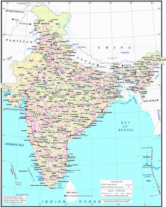
Rural Population
Download Free
National School Atlas
Map depicting distribution of rural population ...
Map depicting distribution of rural population in India as per 2011 census.
pdf
wms
GIS service (1)
Metadata
2020
Urban Population
Collect Free
National School Atlas
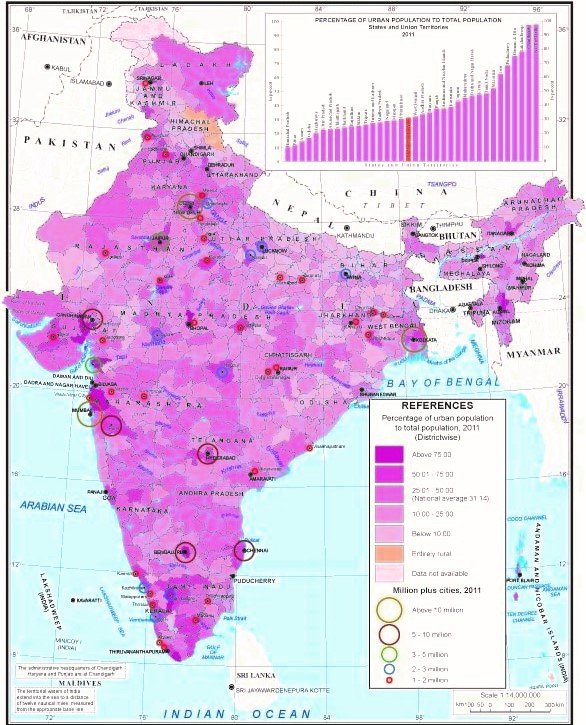
Map showing percentage of urban population to t...
Map showing percentage of urban population to total population 2011.
pdf
wms
GIS service (1)
Metadata
2020
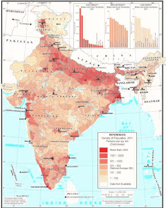
Density of Population
National School Atlas
Data shows Density Of Population of India with ...
Data shows Density Of Population of India with spatial reference
pdf
wms
GIS service (1)
Metadata
2020
Sex Ratio
Download Free
National School Atlas
Map showing district wise sex ratio (number of ...
Map showing district wise sex ratio (number of females per 1000 males) 2011.
pdf
wms
GIS service (1)
Metadata
2020
Scheduled Castes
National School Atlas
Data shows Schedule Castes population of India ...
Data shows Schedule Castes population of India with spatial reference
wms
GIS service (1)
Metadata
2020
Scheduled Tribes
National School Atlas
Data shows Schedule Tribes Population of India ...
Data shows Schedule Tribes Population of India with spatial reference
pdf
wms
GIS service (1)
Metadata
2020
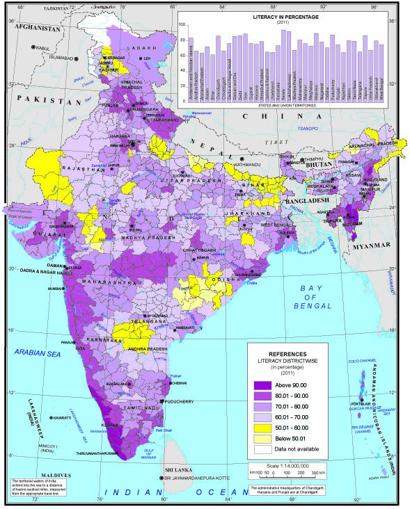
Literacy
National School Atlas
Data shows Literacy of India with spatial refer...
Data shows Literacy of India with spatial reference
pdf
wms
GIS service (1)
Metadata
2020
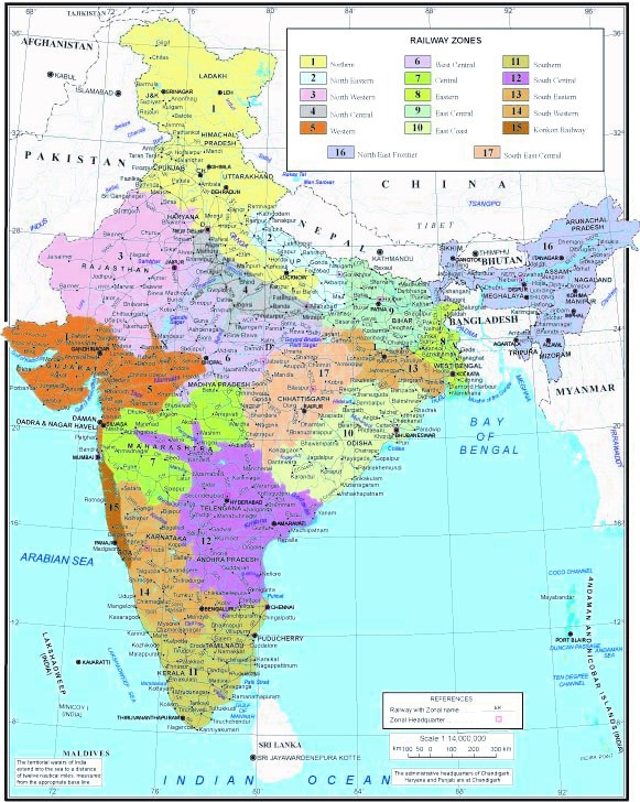
Railways
National School Atlas
Data shows Railway Zone of India with spatial r...
Data shows Railway Zone of India with spatial reference
pdf
wms
GIS service (1)
Metadata
2020
National Highways
National School Atlas
Data shows Roadways of India with spatial refer...
Data shows Roadways of India with spatial reference
pdf
wms
GIS service (1)
Metadata
2020
Port, Sea Routes and Inland Waterways
National School Atlas
Data shows Port,Sea routes and Inland waterways...
Data shows Port,Sea routes and Inland waterways of India with spatial reference
pdf
wms
GIS service (1)
Metadata
2020
Airways
National School Atlas
Data shows Airways of India with spatial refere...
Data shows Airways of India with spatial reference
wms
GIS service (1)
Metadata
2010
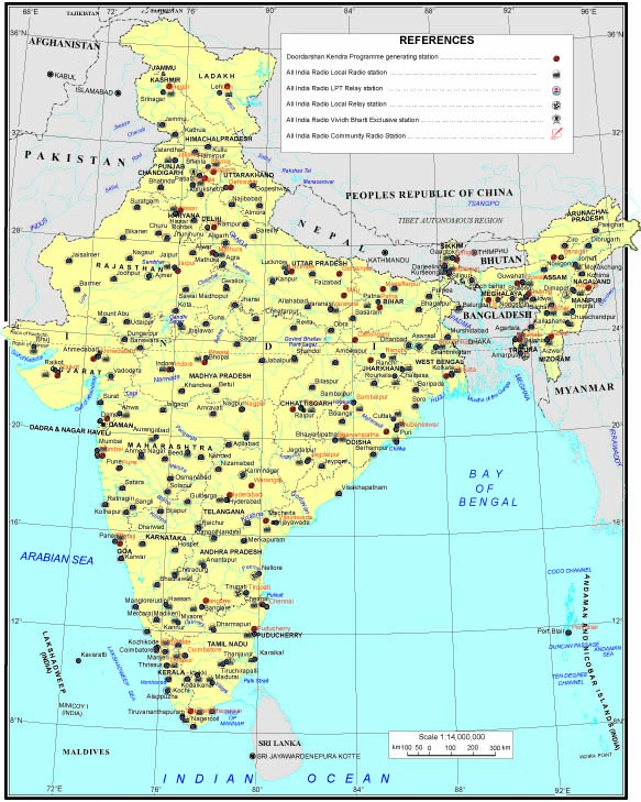
Electronic Media
National School Atlas
Data shows Electronic Media of India with spati...
Data shows Electronic Media of India with spatial reference
pdf
wms
GIS service (1)
Metadata
2020
1
2
3
4
5
6
7
8
9
…
अगला >
अन्तिम »
Map Services/Atlas
Agricultural Atlas (1)
Apply Agricultural Atlas filter
Atlas of Rural India (20)
Apply Atlas of Rural India filter
Indian Ocean Atlas (1)
Apply Indian Ocean Atlas filter
Irrigation Atlas (2)
Apply Irrigation Atlas filter
National Atlas (56)
Apply National Atlas filter
National School Atlas (12)
Apply National School Atlas filter
Postal Service (1)
Apply Postal Service filter
Science and Technology Atlas of India (4)
Apply Science and Technology Atlas of India filter
Social Environs (1)
Apply Social Environs filter
Socio-economic Atlas (11)
Apply Socio-economic Atlas filter
State Atlas (23)
Apply State Atlas filter
Water Resource Atlas (1)
Apply Water Resource Atlas filter
Themes
Demography
Remove Demography filter
Infrastructure, Utility and Services
Remove Infrastructure, Utility and Services filter
Transport and Communication
Remove Transport and Communication filter
-All (1320)
Apply -All filter
Administrative and Political (128)
Apply Administrative and Political filter
Agriculture (99)
Apply Agriculture filter
Banking and Financial Services (19)
Apply Banking and Financial Services filter
Climate (69)
Apply Climate filter
District Planning Map Series (282)
Apply District Planning Map Series filter
Education (26)
Apply Education filter
Environment (15)
Apply Environment filter
Forest and Vegetation (17)
Apply Forest and Vegetation filter
Geology (17)
Apply Geology filter
Golden Map Services (32)
Apply Golden Map Services filter
Ground Water Available For Irrigation (1)
Apply Ground Water Available For Irrigation filter
Handcrafts (1)
Apply Handcrafts filter
Health (28)
Apply Health filter
History and Culture (18)
Apply History and Culture filter
Housing and Settlement (19)
Apply Housing and Settlement filter
Hydrology (75)
Apply Hydrology filter
Industries (18)
Apply Industries filter
Industry (3)
Apply Industry filter
Landuse-Landcover (53)
Apply Landuse-Landcover filter
Livestock, Poultry and Fisheries (10)
Apply Livestock, Poultry and Fisheries filter
Natural Hazards (6)
Apply Natural Hazards filter
Natural Resources (16)
Apply Natural Resources filter
Oceanography (15)
Apply Oceanography filter
Physiography and Geomorphology (59)
Apply Physiography and Geomorphology filter
Planning and Programme Implementation (8)
Apply Planning and Programme Implementation filter
Power and Energy Resources (4)
Apply Power and Energy Resources filter
Science and Technology (7)
Apply Science and Technology filter
Social Environs (17)
Apply Social Environs filter
Soil (31)
Apply Soil filter
Tourism (53)
Apply Tourism filter
Trade and Commerce (13)
Apply Trade and Commerce filter
Wildlife (9)
Apply Wildlife filter
Country
India (133)
Apply India filter
State
Goa (9)
Apply Goa filter
Maharashtra (7)
Apply Maharashtra filter
Punjab (7)
Apply Punjab filter
Scale
1: 14000000 (12)
Apply 1: 14000000 filter
Data Type
Raster (132)
Apply Raster filter
Vector (22)
Apply Vector filter
×
Meta-data
Geoportal
Description
×
Link for WFS.
http://geoportal.natmo.gov.in:1213/NSA_geology_publish_ws